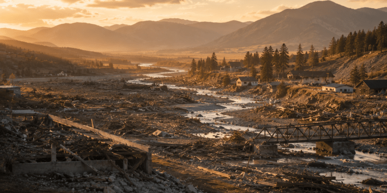
The 1976 Teton Dam flood remains one of the most significant disasters in Eastern Idaho history. It reshaped entire towns and changed how the region approaches floodplains. For homebuyers exploring Fremont, Madison, and Jefferson counties today, this event still matters. It helps explain current land use rules, insurance requirements, and even why some neighborhoods look the way they do.
The dam failed on June 5, 1976, just as its reservoir filled for the first time. Within hours, a wall of water swept downstream. The disaster killed 11 people and destroyed entire communities. It also caused billions of dollars in damage. Nearly 50 years later, its effects still shape Eastern Idaho real estate.
- What Happened During the 1976 Teton Dam Flood?
- Which Communities Were Hit Hardest?
- The Long-Term Recovery Effort
- How the Flood Changed Eastern Idaho Real Estate and Development
- Floodplain and Insurance Considerations for Today’s Buyers
- Visiting the Teton Dam Site Today
- Frequently Asked Questions
- Work With a Local Eastern Idaho Real Estate Expert
- The 1976 Teton Dam Flood: What It Means for Buyers Today
What Happened During the 1976 Teton Dam Flood?
The Teton Dam sat on the Teton River near Newdale, in Fremont County. The U.S. Bureau of Reclamation built the earthen dam, which began filling with water in the fall of 1975. On the morning of June 5, 1976, workers noticed muddy seepage near the dam’s base. Within hours, that seepage grew into a full breach.
The embankment gave way around 11:55 a.m. More than one million cubic feet of water per second poured through the gap. The flood raced downstream and hit the small towns of Wilford and Sugar City almost immediately. From there, it surged toward Rexburg, Idaho Falls, and Blackfoot.
Here are the numbers that show the scale of the disaster:
- 11 people died, including five in Wilford alone.
- About 16,000 head of livestock were killed.
- 1,014 homes were completely destroyed.
- 2,620 homes suffered severe damage.
- The flood inundated more than 300 square miles across five counties.
- Total damage estimates reached roughly $2 billion.
Which Communities Were Hit Hardest?
Wilford and Sugar City took the worst of the flood. Both towns sat directly in the flood’s path. The disaster largely wiped both towns off the map. Survivors rebuilt both communities, but the layout and population of each town changed permanently.
Rexburg absorbed major damage as floodwaters pushed through downtown and residential areas. Recovery took years. Much of the city’s current infrastructure reflects lessons learned from that rebuilding effort. Farther downstream, Idaho Falls and Blackfoot saw flooding too. However, the impact eased as the water spread across the wider Snake River plain.
Today’s residents notice the effects in subtle ways. A guide to living in Idaho Falls can help explain how the city’s flood history shaped its modern drainage systems and building codes.
The Long-Term Recovery Effort
Recovery from the 1976 Teton Dam flood took years, not months. Federal disaster relief funded rebuilding across Fremont, Madison, and Bonneville counties. The Small Business Administration and FEMA’s predecessor agencies processed thousands of claims throughout the late 1970s and into the 1980s.
Local farmers faced a particularly hard road. Floodwaters stripped topsoil from thousands of acres of farmland. Many families rebuilt homes on the same land, while others relocated to higher ground nearby. That pattern of rebuilding shaped the layout of several communities that still exist today.
How the Flood Changed Eastern Idaho Real Estate and Development
The Teton Dam failure permanently altered how Eastern Idaho approaches floodplain development. Local governments updated building codes, drainage systems, and land-use planning after 1976. Many of these updates still influence where and how new subdivisions get approved today.
The federal government paid out hundreds of millions of dollars in claims following the disaster. That payout history, combined with the physical damage, pushed local zoning boards to act. They rethought construction rules near the Teton and Snake Rivers. As a result, some low-lying parcels near the original flood path carry stricter building requirements than nearby areas.
Buyers researching new housing developments in Eastern Idaho should ask a simple question. Does the property sit inside a mapped floodplain? Builders in the region generally account for this. However, older properties near the original flood path may carry different requirements than newer construction.
Floodplain and Insurance Considerations for Today’s Buyers
Homebuyers in Fremont, Madison, and Jefferson counties should understand FEMA flood zone designations before making an offer. A property inside a mapped floodplain typically requires flood insurance. This applies when the home carries a federally backed mortgage. The requirement holds true whether or not the home sits near the original 1976 flood path.
Lenders usually order a flood certification during the loan process. This step confirms whether a specific parcel falls inside a FEMA-designated flood zone. Buyers should review this certification carefully. Don’t assume a property’s flood risk based on general area reputation alone.
Market timing matters too. It helps to check whether it’s a good time to buy a home in Idaho Falls before finalizing any purchase decision, since timing and flood zone factors work together.
Visiting the Teton Dam Site Today
The Teton Dam was never rebuilt after its failure. Today, the site sits along the Teton River canyon as a quiet reminder of the disaster. Visitors can view the remaining canyon walls and read historical markers. These markers explain the timeline of the failure in detail.
Many longtime Eastern Idaho residents still share memories of the flood. Several local museums display photographs and artifacts from the disaster. For homebuyers curious about the area’s history, a visit offers useful context. It’s worth stopping by before settling into a nearby community.
Frequently Asked Questions
Was the Teton Dam ever rebuilt?
No. The federal government chose not to rebuild the dam after the 1976 failure. The site remains an open canyon today, with historical markers explaining what happened.
Does the Teton Dam disaster affect flood insurance requirements today?
The disaster itself doesn’t directly set today’s flood insurance rules. However, it did prompt Eastern Idaho communities to update floodplain mapping and building codes. Those updates still influence insurance requirements for certain properties.
Which areas were hit hardest by the flood?
Wilford and Sugar City suffered the most severe damage and were largely destroyed. Rexburg also absorbed significant flooding. Idaho Falls and Blackfoot saw lesser impacts farther downstream.
Is the area safe to live in now?
Yes. Eastern Idaho has rebuilt and grown significantly since 1976. Modern building codes and floodplain regulations help manage flood risk for new construction throughout the region.
Can I visit the Teton Dam site?
Yes. The dam site sits along the Teton River canyon near Newdale, and it remains open to visitors. Local museums in the area also display photographs and information about the 1976 disaster.
Work With a Local Eastern Idaho Real Estate Expert
If you’re exploring homes in areas shaped by the 1976 Teton Dam flood, it helps to work with an agent who actually knows the area. Valorie Blanchard of Valorie’s List @ Idaho’s Real Estate is a lifelong Eastern Idaho resident, born in Rexburg and raised on a family farm that’s been in her family since the 1800s. She’s an Associate Broker and GRI Graduate with a decade of experience helping buyers and sellers throughout Idaho Falls, Rexburg, and the surrounding communities, backed by a strong digital marketing background and firsthand knowledge of the local market. Learn more about Valorie or reach out directly for current listings.
The 1976 Teton Dam Flood: What It Means for Buyers Today
The 1976 Teton Dam flood remains a defining moment in Eastern Idaho history. Its influence still shapes local development decisions today. Understanding the disaster helps explain current floodplain rules, building codes, and insurance requirements. Whether you’re drawn to Rexburg, Sugar City, or the wider Idaho Falls area, a little historical context makes for a smarter, more informed purchase.